

ADOPT
AI for Detecting Ocean Plastic Pollution with Tracking
Abstract
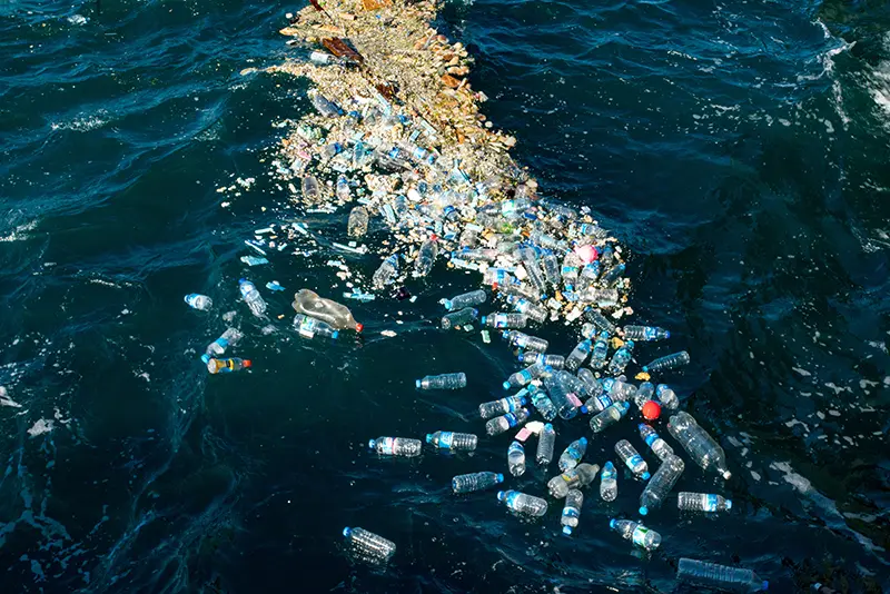
Marine litter is a growing ecologic concern that needs to be addressed at a global scale. While satellite and meteorological data is available in abundance, few advances have been made towards continuous monitoring of marine litter aggregated in floating patches on the oceans. To address this, we propose ADOPT, a hybrid model to automatically identify marine litter from satellite imagery and predict its location given meteorological information. In the first instance, ADOPT contains a deep learning-based detection module to identify aggregations of floating debris. In a second instance, it employs a physical drift estimation module to project the pathway of detected debris in space and time. These modules ingest Sentinel-2 and PlanetScope satellite time series as well as meteorological data to provide up-to-date, high-resolution estimates of the locations of floating objects. This is crucial for on-site ship-based cleanup efforts that rely on accurate and timely information on floating litter islands for efficient collection. Automating floating debris detection poses several challenges: the domain shift between the globally distributed satellite scenes is strong; the small footprint of debris induces a severely imbalanced dataset; a visual identification of debris is difficult even for experts; noisy and incomplete labels pose challenges to automated machine learning methods. The two-layered strategy tackles these issues, where the segmentation module is aided by a machine-learning-based tracking module. Addressing this real-world challenge in a physically sound manner will provide a unique opportunity to deploy methods beyond idealized benchmarks, and with ecological impact, providing cleanup missions with up-to-date and physically plausible marine litter location estimations.
People
Collaborators
Christian joined SDSC in 2019 to design data-driven solutions to support academic research projects. His research interests comprise inference of probabilistic models, with a focus on nonparametric models, and stochastic processes. He holds a PhD in Computational Neuroscience from the Technical University Berlin, Germany, a MSc from the Bernstein Center for Computational Neuroscience Berlin, and a BSc in Cognitive Science from the University of Osnabrück, Germany. During the course of his studies, he additionally conducted research at Khalifa University (UAE), Strathclyde University (UK), and the RIKEN Brain Science Institute and the Kyoto University in Japan. Before joining SDSC, he was an intern at Amazon CoreAI in Berlin.



Shirin obtained her PhD in Data Science from ETH in 2024 where she focused on evaluation of high-dimensional probabilistic generative models with sequential sampling algorithms. As a Marie Skłodowska-Curie fellow, she had the opportunity to visit and collaborate with researchers at the Machine Learning groups at UC3M and Eurecom, gaining experience in parameteric and non-parameteric probabilistic models, stochastic differential equations, and optimal transport approximators. Shirin has a keen interest in studying complex stochastic dynamical systems and their application to climate and environmental sciences.

Michele Volpi holds a Ph.D. in Environmental Sciences from the University of Lausanne (2013). He was a postdoctoral researcher in the CALVIN group at the University of Edinburgh’s School of Informatics (2014–2016), and then a member of the Multimodal Remote Sensing and Geocomputation groups at the University of Zurich’s Department of Geography (2016–2017). He joined SDSC in 2018 as Senior Data Scientist in the Research Team and became Lead Data Scientist in 2022. Since 2025, Michele serves as Climate and Environment Domain Lead, overseeing SDSC’s activities in this area. He leads projects in geospatial machine learning, working with Earth observation and geolocated spatio-temporal data, with applications in climate and weather, ecology, natural hazards, and agriculture, among others. Michele is also a Lecturer in the Department of Environmental Systems Sciences at ETH Zurich.
description
Motivation
Marine litter is accumulating at alarming rates, with 19 to 23 million metric tonnes dispersed in 2016 alone (Borrelle et al., 2020). Plastic artifacts constitute 75% of marine litter, exceeding 5 trillion objects in numbers (Eriksen et al., 2014) and are causing a serious threat to marine ecosystems, climate, and the human food chain. To understand the dynamics of plastic debris and finally remove it from the eco-system it is key to automatize large-scale detection.
Proposed Approach / Solution
This project aims at tracking plastic debris in the ocean with satellite imagery. This involves two modules (see Figure 1):
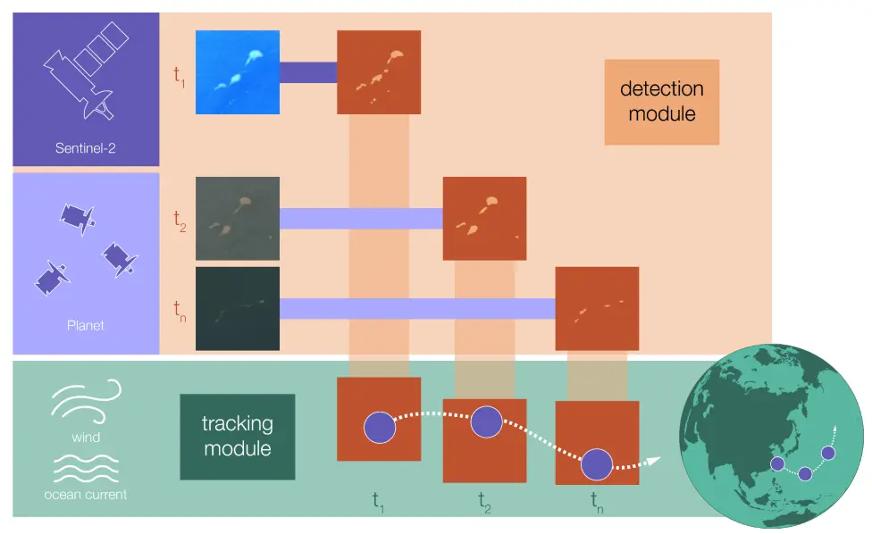
1) Debris detection: Utilizing Segmentation algorithms, e.g. UNET++ (Russwurm et al., 2023), to efficiently detected plastic debris on satellite images. In (Dalsasso et al., 2026) we utilizeed self-supervised machine learning approach allowing for accurate predictions with scarce labels on PlanetScope imagery (see Figure 2 for an example) and fused them with Sentinel2 images.
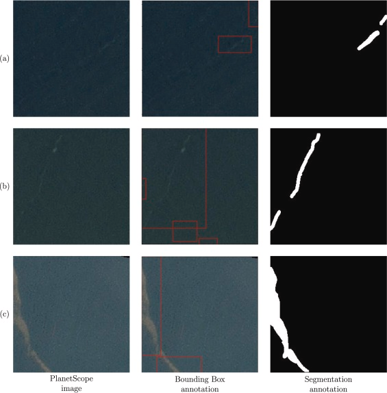
Figure2: Satellite image data of marine debris with annotations. Left: Raw image. Center: Pre-existing bounding boxes. Right: Our pixel level annotation. White areas mark debris pixels, we want to predict. Source: Dalsasso et al., 2026
2) Debris tracking: In (Donner et al., 2026) we developed a machine learning model called CoDiT (Conditional Diffusion model for Trajectories), that can predict the trajectories of floating objects for multiple days based on currents and wind. We considered two global datasets, one focusing on open ocean, and one on coastal areas. We showed state-of-the-art performance comparing to several baselines.
Impact
Combining the two modules enables “AI for Detecting Ocean Plastic Pollution with Tracking” (ADOPT). This allows to not only detect litter objects with high accuracy but also provide a timely estimate of future locations, thanks to its ability to process images of different satellite sensors and the inclusion of a probabilistic ocean drift module for tracking.
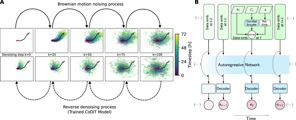
Figure 3: Diffusion model to predict floating objects' trajectories. The denoising model (named CoDiT) learns how to transform noisy trajectories into probable trajectories given information about currents and wind. A: And example of the noising and denoising process. B: The model architecture of CoDiT. Source: Donner et al., 2026
Presentation
Gallery
Annexe
Publications:
- Dalsasso, E., Rußwurm, M., Donner, C., Darmon, S., de Vries, R., Volpi, M., & Tuia, D. (2026). Self-supervised pre-training enables marine debris detection across sensors. Remote Sensing of Environment, 339, 115391.
- Donner, C., Goshtasbpour, S., Dalsasso, E., Romero, M., Béchaz, M., Rußwurm, M., ... & Volpi, M. (2026). CoDiT: conditional diffusion models for multi-day ocean drifter trajectory prediction. Machine Learning: Earth, 2(2), 025012.
- Donner, C., Goshtasbpour, S., Dalsasso, E., Volpi, M., Russwurm, M., & Tuia, D. (2025, April). Autoregressive denoising diffusion for predicting trajectories of floating objects in oceans. In EGU General Assembly Conference Abstracts (pp. EGU25-11223).
- GitHub: GitHub - SwissDataScienceCenter/CoDiT
- Dataset: CoDiT - ocean drifter trajectory datasets
Additional resources
Bibliography
- Borrelle, S. B., Ringma, J., Law, K. L., Monnahan, C. C., Lebreton, L., McGivern, A., ... & Rochman, C. M. (2020). Predicted growth in plastic waste exceeds efforts to mitigate plastic pollution. Science, 369(6510), 1515-1518. DOI: 10.1126/science.aba3656
- Eriksen, M., Lebreton, L. C., Carson, H. S., Thiel, M., Moore, C. J., Borerro, J. C., ... & Reisser, J. (2014). Plastic pollution in the world's oceans: more than 5 trillion plastic pieces weighing over 250,000 tons afloat at sea. PloS one, 9(12), e111913. DOI: 10.1371/journal.pone.0111913
- Carmo, R., Mifdal, J., & Rußwurm, M. (2021, September). Detecting macro floating objects on coastal water bodies using Sentinel-2 data. In OCEANS 2021: San Diego–Porto (pp. 1-7). IEEE. DOI: 10.23919/OCEANS44145.2021.9705668
- Russwurm, M. C., Gül, D., & Tuia, D. (2023, April). Improved marine debris detection in satellite imagery with automatic refinement of coarse hand annotations. In 11th International Conference on Learning Representations (ICLR) Workshops.
Publications
More projects

ALBUM

AICADES
IICU National Data Stream
SMARTT
More projects
News
Latest news

Quand l’IA soutient l’économie du canton de Vaud, la santé et l’environnement
Quand l’IA soutient l’économie du canton de Vaud, la santé et l’environnement

Elevating International Geneva's Impact with AI
Elevating International Geneva's Impact with AI
12 Zurich SMEs join next AI Innovation Program
12 Zurich SMEs join next AI Innovation Program
Contact us
Would you like to explore how we can work together?
Our team of data scientists and professionals looks forward to engaging in impactful, results-driven collaborations with you.